2021 University of Delaware Student Competition for
Geospatial Data Visualization / Map Design
This is an annual recurring event sponsored and administered by the Department of Geography and Spatial Sciences (GEOG) and the Data Science Institute (DSI) at UD. The 2021 cycle is now complete. UD students at all levels entered the university-wide competition for achievements in the art and science of mapping geospatial data. Here is the archived call for submissions which were closed on Oct 1, 2021. Here is a UDaily article about the 2021 winners.
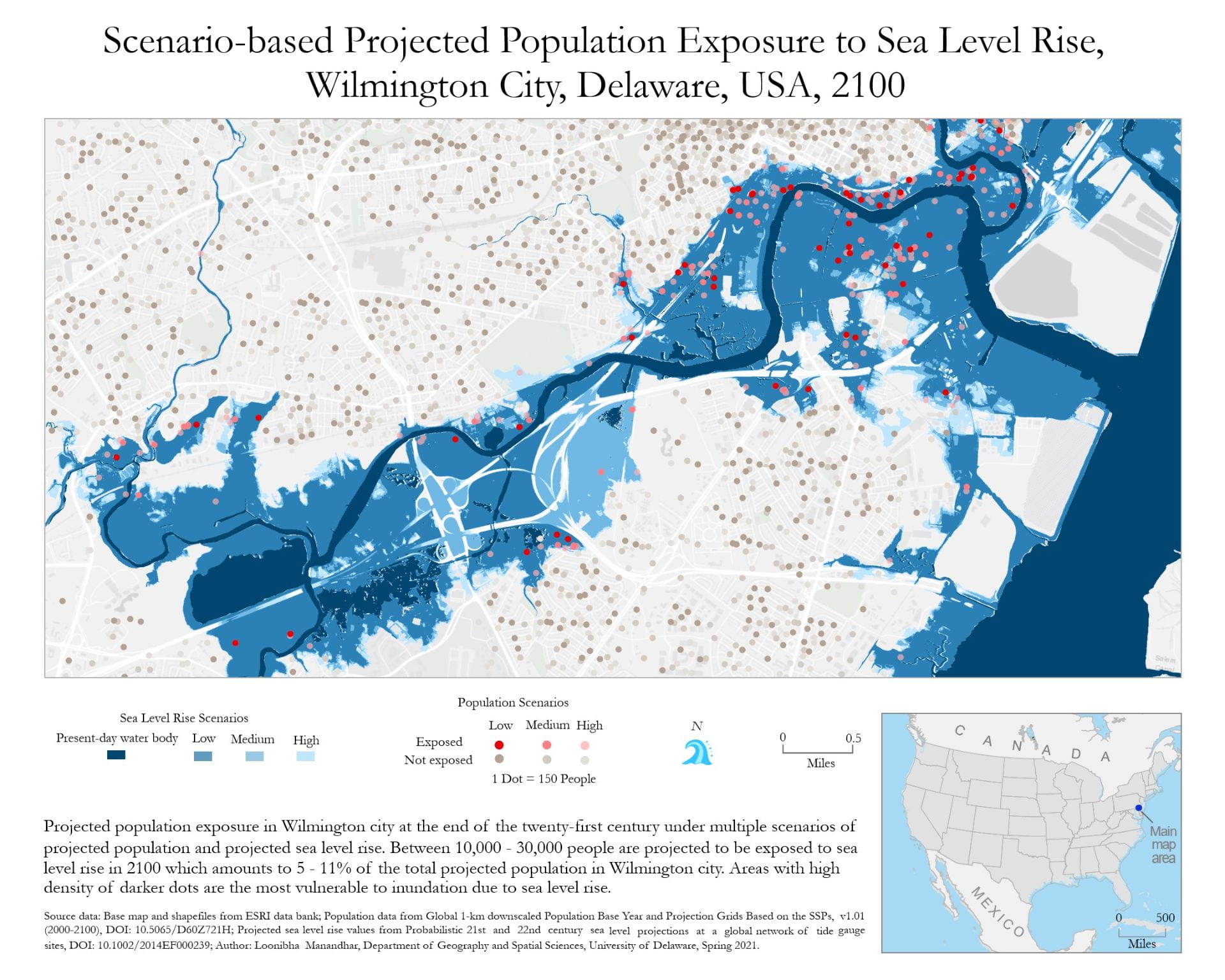
Map Title: Scenario-based Projected Population Exposure to Sea Level Rise, Wilmington City, Delaware, USA, 2100
Background: This is a dot density map that shows projected population exposure at the end of the 21st century in Wilmington, DE under multiple projected scenarios of sea level rise and population. Exposed (red dots) as well as un-exposed (brown dots) population are represented, where 1 dot = 150 people. High dot density indicates high population density. The saturation of the dots shows the probability of exposure, i.e., if people in a particular area are likely to be exposed under multiple scenarios, the dots are darker in color. This means that places with higher densities of darker red dots are the most vulnerable, because there are likely a higher number of people who might be exposed to inundation hazards under multiple scenarios. This map can be used to estimate the number of people, their
locations, and likelihoods to be exposed to coastal floods at the end of the 21st century. The dots were automatically generated using ArcMap and have been manually adjusted to remove artificial spatial patterns in dot placement that the underlying data do not represent.
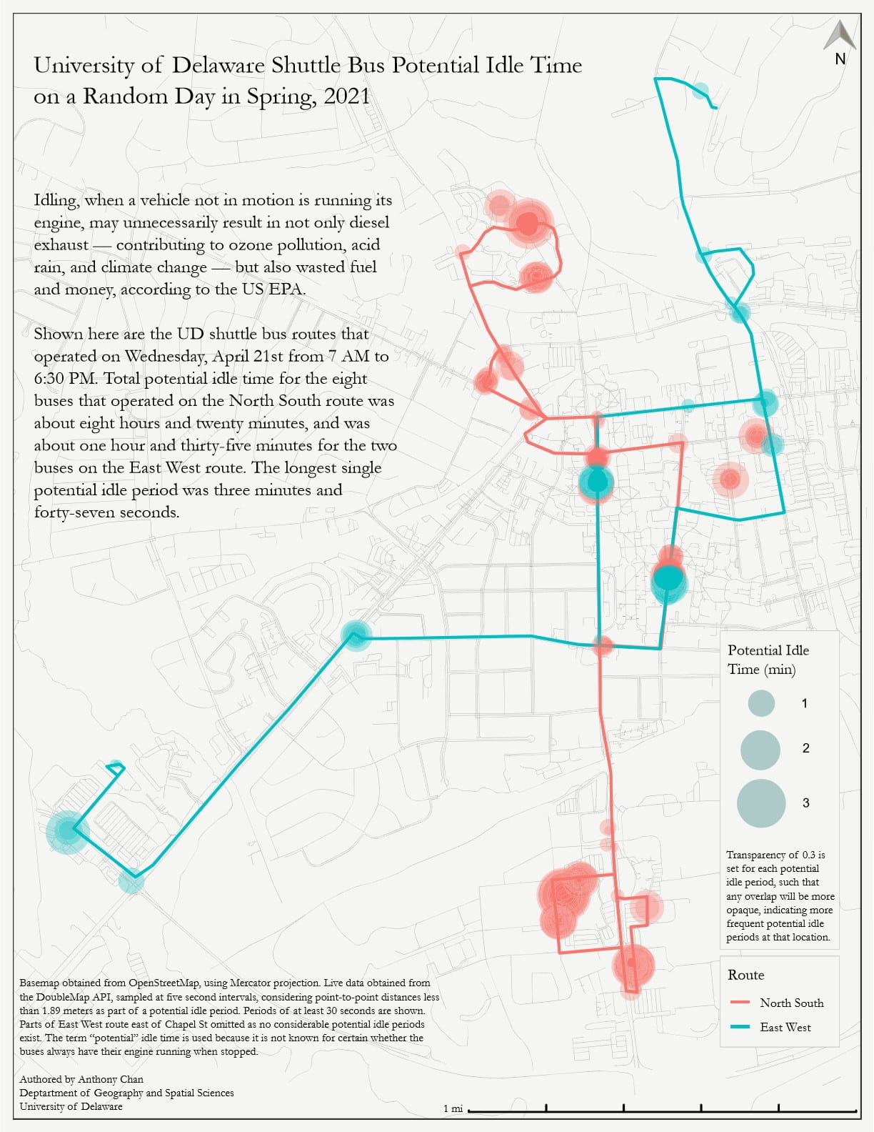
Map Title: University of Delaware Shuttle Bus Potential Idle Time on a Random Day in Spring 2021
Background: Taking the UD Shuttle Bus to class, I was curious about how long the bus stayed at each stop since idling can be a preventable source of air pollution. Using R, I sampled live data from the DoubleMap API on April 21, 2021 (a random day in spring 2021), constructing a dataset for the buses running on that day. I then displayed the potential idle periods using a proportional symbol map with larger circles indicating longer periods and darker colors indicating overlap of idle periods. A word of caution, however, is that the map is only showing a proxy for idling as it is not known for certain whether the buses always run the engine while stopped.
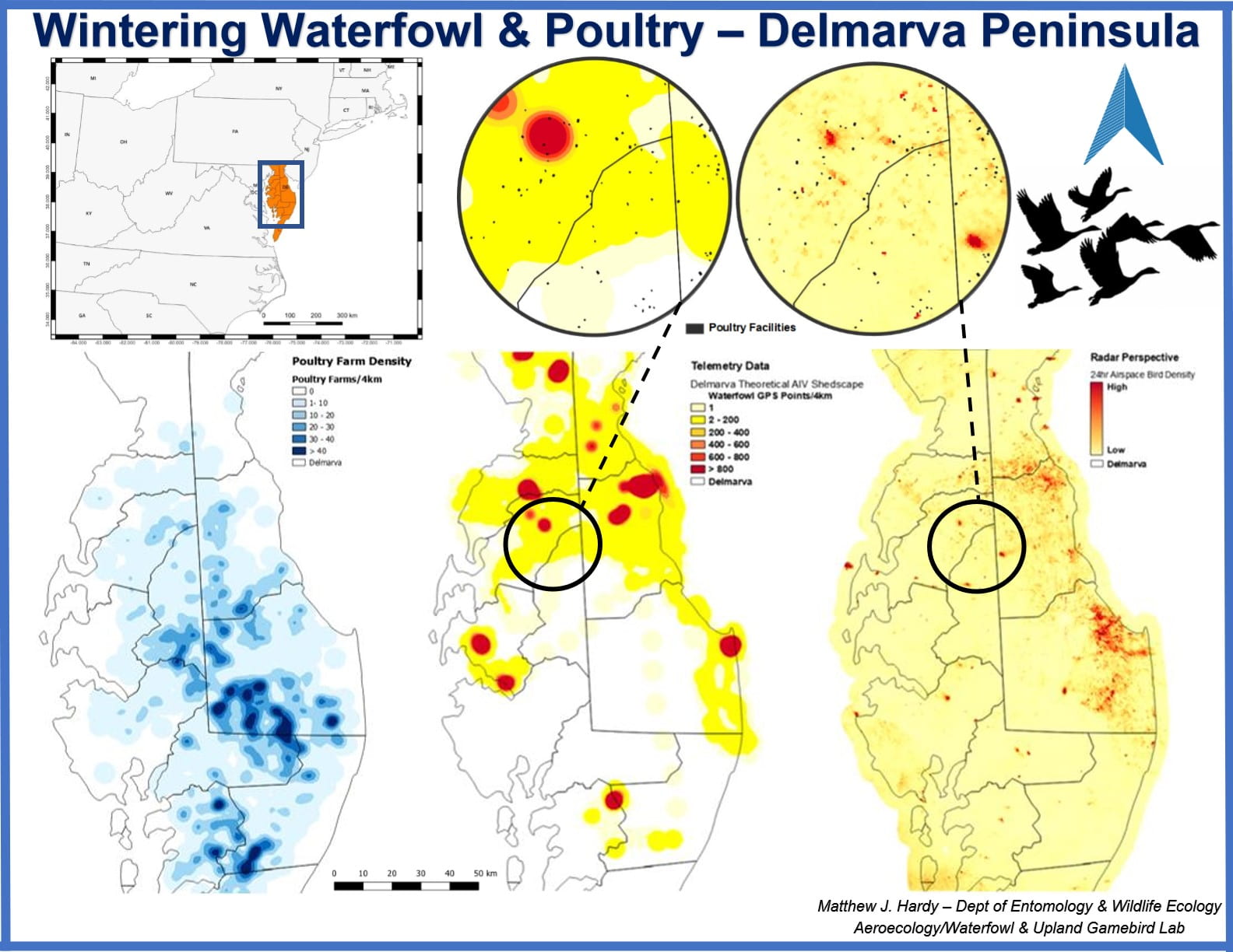
Matthew Hardy (mjhardy@udel.edu)
M.S. student in Wildlife Ecology
Prize
- Cash awards and acknowledgement certificates for a winner ($300) and a runner-up ($200)
- Competitive entries are featured right here on the competition webpage and at UD GIS Day (Nov 17, 2021), and used by UD educators as examples of excellent map design (with permission)
Eligibility
- The map entry must have been completed between Sep 1, 2020 and Sep 30, 2021 (roughly, the past academic year)
- You do not have to be a student at the time of the submission, but you must have been a UD student when you completed the map
- Students may submit multiple entries, but may only win one prize
- Group work is eligible, but the maximum number of students working on a single map is two
Judging Criteria
Map entries are judged on clarity, originality, and creativity in both the art and the science of mapping, while appropriate use of geospatial data and technologies is a must. All entries are judged by an expert panel of geospatial data scientists at UD. The award will be announced near the end of October.
Our Mission
The Institute aims to accelerate research in data science, serving as a nucleating effort to catalyze interdisciplinary research collaborations across fields impacting our society.


