2020 Inaugural University of Delaware Student Competition for
Geospatial Data Visualization / Map Design
This is an annual recurring event sponsored and administered by the Department of Geography and Spatial Sciences (GEOG) and the Data Science Institute (DSI) at UD. The 2020 cycle is now complete. UD students at all levels entered the university-wide competition for achievements in the art and science of mapping geospatial data. Here is the archived call for submissions which were closed on Oct 1, 2020. Here is a UDaily article about the 2020 winners.
The 2020 Winners
Winner: Bridgette Kegelman (Breir.BK@gmail.com), B.A. in Geography & B.A. in Ancient Greek and Roman Studies, Class of 2021
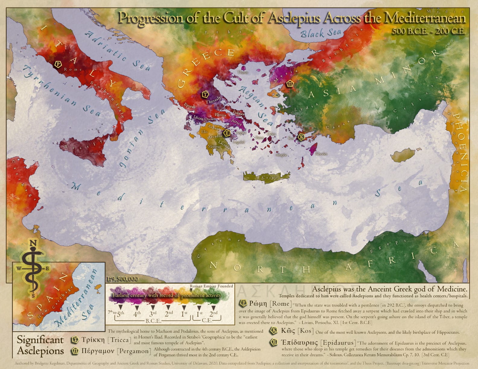
Map Title: Progression of the Cult of Asclepius across the Mediterranean 500 B.C.E. – 200 C.E.
Background: Asclepius was the ancient Greek god of medicine. His temples functioned as hospitals/healing centers, and his followers acted as doctors. The cult of Asclepius held the main collective knowledge on medicine in this period, so I thought it would be useful to understand the spread of this ideology and knowledge over time by visualizing it geographically. It should be noted that in this time period, the word cult had different connotations and referred to something we may consider more like a religious sect today. I wanted the map to feel pseudo-old and handmade, yet regal and clean, since it is displaying the story of an ancient god of medicine. I also wanted a style that could show how the borders between regions were not rigid because the spreading of knowledge is a gradual progression. To accomplish this, I chose a painted stylization to create a kind of abstract chloroplast. I interpolated this chloroplast from locations and dates tied to text fragments we have found referring to the presence of the cult. The five points noted on top of the progression are the most significant Asclepions (temples of Asclepius), and famous fragments and/or details are included in the legend for these.
Winner: Jessie Eastburn (jessie.eastburn@gmail.com), B.S. in Geological Sciences, Class of 2020
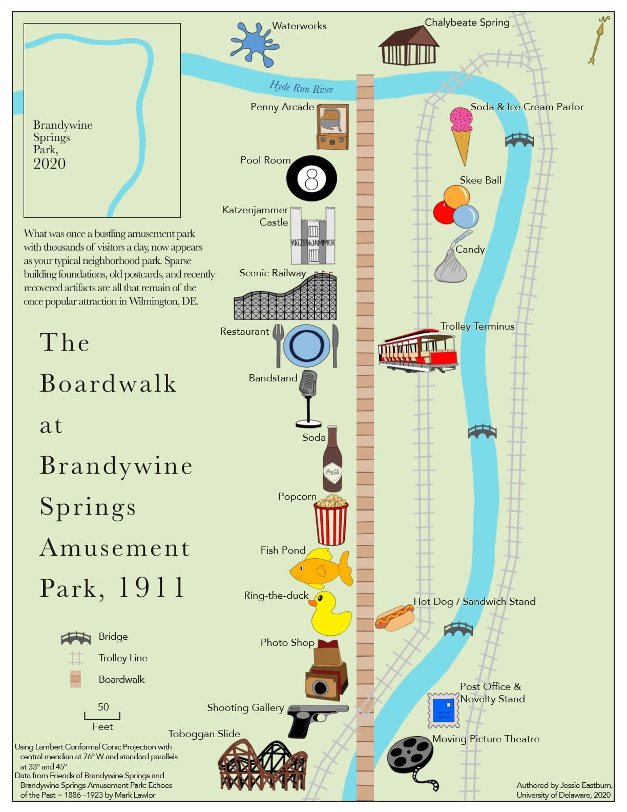
Map Title: Brandywine Springs Park, Wilmington, DE in 1911 vs. 2020
Background: The currently unassuming Brandywine Springs Park, located in Wilmington, Delaware, was once home to an immensely popular amusement park from the years 1886 to 1923. This map was designed to be used by a patron of the park in 1911 to navigate the many amusements surrounding the park boardwalk that year. For a more current park patron, this map is useful for someone looking to walk through the area and get a feel for its rich history and the former locations of its amusements. Mapping methods involve the use of satellite imagery to georeference the park to a hand drawn map of the area. The remnants of the trolley line can also be seen on satellite imagery, so the amusement locations relative to the trolley line were further determined from this information. All symbols on the map were digitally drawn or traced and then colored to create a more cohesive color scheme and overall aesthetic. The image used for the trolley terminus was created by digitally tracing a photo of one of the original trolleys used in the park.
Prize
- Cash awards and acknowledgement certificates for our two winners
- Competitive entries are featured right here on the competition webpage and at UD GIS Day (Nov 18, 2020), and used by UD educators as examples of excellent map design (with permission)
Eligibility
- The map entry must have been completed between Sep 1, 2019 and Sep 30, 2020 (roughly, the past academic year)
- You do not have to be a student at the time of the submission, but you must have been a UD student when you completed the map
- Students may submit multiple entries, but may only win one prize
- Group work is eligible, but the maximum number of students working on a single map is two
Judging Criteria
Map entries are judged on clarity, originality, and creativity in both the art and the science of mapping, while appropriate use of geospatial data and technologies is a must. All entries are judged by an expert panel of geospatial data scientists at UD. The award will be announced near the end of October.
Further questions about the competition can be directed to Dr. Jing Gao (jinggao@udel.edu).


